
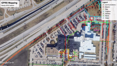
Hospital Scan in Dallas-Fort Worth, Texas
We recently scanned a large portion of a hospital in the DFW area. The scan encompassed about 15 acres and the customer requested that GPRS mark out the locations of all utilities on site as shown above. When we approach a large project like this, we use a tested GPR methodology to ensure that the scan is comprehensive. SIM (Subsurface Investigation Methodology) includes the following steps: To begin, we search the site for visible signs of utilities, and then we open up utility features (as needed) and use the EM Locator to induce a tone onto anything conductive. By inducing a tone onto each utility, we can follow it and mark it on the surface, and we can get some idea of the depth of the line. Additionally, we know what utility is being toned, so we can generally identify the utility correctly, though this is not always the case. Sometimes, the tone can jump from one utility to another, creating confusion. It is always best to pothole our findings to verify whether all lines are identified correctly.
At this hospital, there was a large sign at the front corner that contained an electrical panel which fed some exterior outlets and site lighting. Unfortunately, this system used the same ground wiring as the irrigation control system nearby, so that when we toned the irrigation, the site lighting showed up, and vice versa. It was very difficult to distinguish between the two, but our experienced technicians were able to tell the difference. By the time we had completed this located, we had a high degree of confidence in our identification of all but two utilities, which were marked with pink, to indicate our uncertainty.
After tying on to all visible utility features in the scan area, we proceeded to the next step of the SIM process, which was to walk the whole site again on Passive mode, which is a mode that can pick up power and radio signals that often run along buried utilities, even when those utilities are not being toned deliberately. We were
able to find a few additional utilities on Passive mode, which did not innitially show up, because they ran through the area without connecting to a visible surface indicator (e.g. a manhole, riser pole, valve, or panel).
Next, we used keys, wrenches, and manhole lift hooks to open up storm and sanitary features in order to get measurements and directions of the associated lines. If we could not identify the path of a line with confidence, we used a traceable rodder to locate the line. To use the rodder, we need an open point of entry into the interior of a line, from which we push the rodder coil into the line. We can then trace the rodder to find the path of the line, including an approximation of its depth. We don't use this method when the path of lines is obvious (e.g. a line that clearly runs between two manholes), but it is a great way to give a precise reading when line directions are unknown.
At this hospital, there was a sanitary line that ran from a manhole directly toward a field where future digging is planned. We did not find another manhole or lift station in that direction, so we were uncertain where the line ran until we attempted to trace it with the rodder. Unfortunately, after inserting the rodder about 80 feet, the rodder hit an obstruction of some sort and could not be inserted further. We marked this point on the surface and notified the customer that the line might be blocked there, or else there might be a T or a turn. This information dramatically narrowed the scope of where the customer needed to pothole in order to identify what was going on with that line. This situation illustrates well the tension of utility locating. Even the best technology has limitations in what it can do to locate utilities, but the latest technology in the hand of experience, SIM compliant technicians can dramatically reduce the risk of utility strikes, as well as save time and narrow the scope of digging that needs to be performed.
To schedule your utility investigation, call Lisa at 214.471.9001.
GPRS does not provide geophysical, geological, land surveying or engineering services. If you need such services, please contact an appropriate professional.